WoSIS – World Soil Information Service

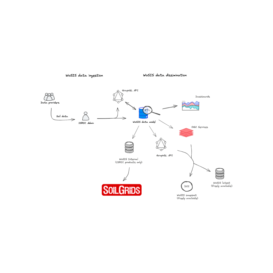
World Soil Information Service (WoSIS) is one of ISRIC’s flagship products. WoSIS is a one-of-a-kind, centralised global soil database, that is managed by ISRIC for the benefit of the international community.

Established in 2013, the original aim of the product was to host any type of soil data, however WoSIS has evolved to safeguard, process and standardise soil profile data from around the world. Today, WoSIS aims to:

  • Safeguard world soil profile data in its originally received format and file (especially for soil legacy data).

  • Quality assess and standardise soil data.

  • Provide standardised soil data for digital soil mapping and a range of environmental applications (in accordance with the licenses and data providers).

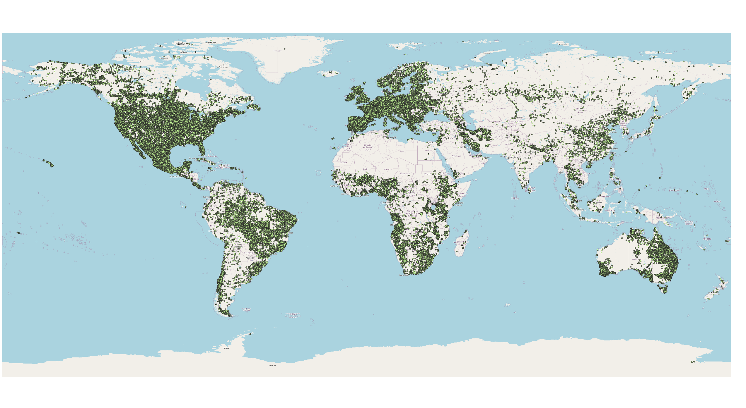
Since its launch, WoSIS has grown through international collaboration, continuously integrating new data and refining its structure and methods to support a wide range of soil and environmental applications. By mid-2025, WoSIS represented over 230,000 georeferenced profiles from 174 countries, corresponding to more than 900,000 soil layers (or horizons), and with over 6 million soil records.

How does WoSIS harmonises data

First, new soil data, in its original file format and considering its accompanying licenses, are imported into the ISRIC data repository. Data are quality-assessed, standardised, and imported into the WoSIS data model itself and, where possible, harmonised using consistent procedures. The data are thereafter mapped to the standard WoSIS naming conventions, standard values and/or units of measurement. Finally, the WoSIS data are made available to the larger international community, or to support DSM applications such as SoilGrids. See Figure 1 below.

/media/i5lhszyl/wosis-workflow.png
Figure 1. WoSIS workflow for ingesting, processing and disseminating data.

Which soil properties are shown in WoSIS?

WoSIS shows these soil chemical properties: organic carbon, total carbon, total carbonate equivalent, total nitrogen, phosphorus (extractable-P, total-P, and P-retention), soil pH, cation exchange capacity, and electrical conductivity.

WoSIS also shows these physical properties: soil texture (sand, silt, and clay), bulk density, coarse fragments, and water retention, grouped according to analytical procedures (aggregates) that are operationally comparable.

For each soil profile, if available, the original soil classification (FAO, WRB, USDA, and version) and horizon designations are provided in WoSIS.

How is WoSIS data used?

WoSIS data are used for digital soil mapping of a number of soil properties, and various regional to global environmental assessments that support food security, biodiversity conservation, climate change mitigation, water management, and land degradation control and rehabilitation.

The products derived from WoSIS are crucial for creating awareness, informing and supporting policymakers, business leaders, and conventions (e.g., the United Nations Convention to Combat Desertification and the United Nations Framework Convention on Climate Change) in making well-informed decisions about the environment, biodiversity, climate change, and human well-being.

Share your soil data and collaborate with ISRIC

Learn more about how to share your data here.

Suggested content